Rezoning Request
Also Known As: Sockwell Corners / Sockwell Village
Planning Commission Meeting: Tues. Feb. 27, 2024, 7:00 PM, Historic Courthouse
Board of Commissioners Meeting: Tues. Mar. 5, 2024, 7:30 PM, Historic Courthouse
Rezoning Request: Change from Agricultural Residential (A.R.) to Community Oriented Residential Development – Planned Residential Commercial (C.O.R.D.- P.R.C.)
Location: Near Hwy 278 and GA Hwy 142 Round About Intersection
Parcel Size: 158 acres (approximately)
Commissioner: District 5 – Ronnie Cowan
Status: Pending
FLUM Request: Click to Review Past Request
Courthouse Meetings
Members of the community are encouraged to attend and comment at the Planning Commission and Board of Commissioner (BoC) meetings.
Both meetings occur on the Covington Square at:
On Tuesday, February 27, 2024, at 7:00 PM the developers will propose Rezoning to the Planning Commission. In the PDF below, you can find the recommendations made by the Staff if the Rezoning is approved. The Planning Commission can make further recommendations to the BoC and Recommend, Not Recommend, or Table the request.
On Tuesday, March 5, 2024, at 7:30 PM the Board of Commissioners will hear the case for the Rezoning request. The BoC can approve or deny the changes recommended by the Planning Commission. The BoC can also approve the Rezoning if the Planning Commission does not recommend it, and vice-versa.
Rezoning Request PDF
The 29 page PDF below is visible on desktops. Phones and tablets will need to download the PDF or click here to open the PDF in another browser tab.
From the PDF above:
Community Meeting Held on February 8th 2024. (page 2)
A Community meeting was held with residents to discuss this proposed development. There were about 75 – 80 residents present. Many expressed concerns about having a high density subdivision at this location. They cited traffic, sewer, and pressure on existing utilities and facilities as reasons they would not want the subdivision located there.
One resident was in favor pointing out that it was better have this type of subdivision concentrated near the highway where they were conserving a portion of the land than to have homes sprawled throughout the eastside.
The applicant noted that with large projects such as Rivian and the business park, there will be a demand for housing and this project met that need while still conserving almost half the development.
DEVELOPMENT OF REGIONAL IMPACT SUMMARY (page 6)
This report contains the NEGRC’s assessment of how the proposed project relates to the policies, programs, and projects articulated in the Regional Plan and Regional Resource Plan. Also included is an assessment of likely inter-jurisdictional impacts resulting from the proposed development, as well as all comments received from identified affected parties and others during the fifteen- day comment period.
Proposed Development
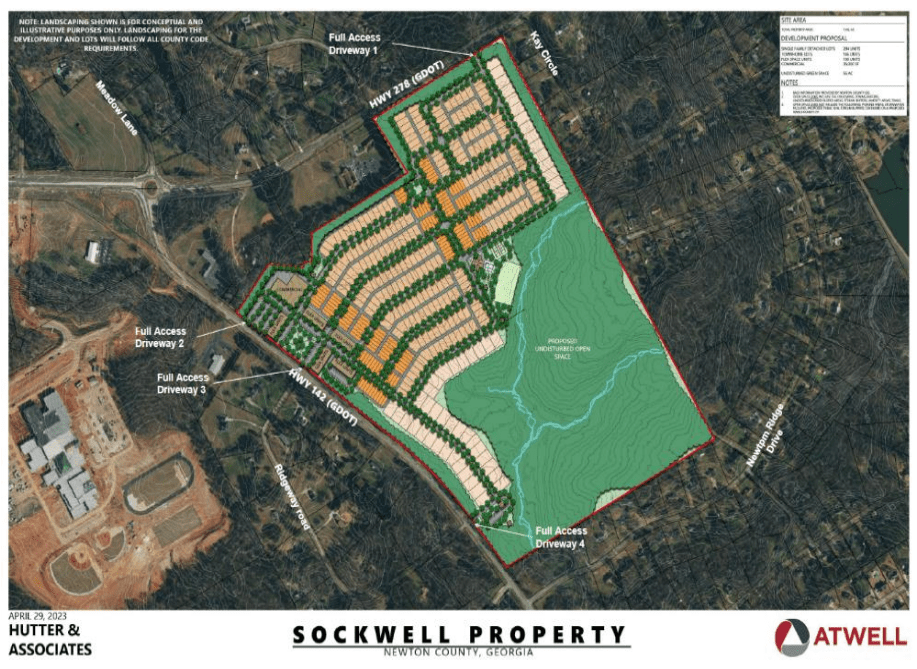
The applicant is proposing construction of a mixed-use development with 610 residential units and 35,000 square feet of commercial space on a 155-acre site in Newton County. The proposed development would consist of a combination of single-family detached homes, attached townhomes, and mixed-use live/work buildings in a traditional town center configuration. The mixed-use portion of the site is situated along Highway 142. Five “flex units” are proposed in this area, which would include 180 condominiums and an unspecified amount of office and commercial space. This area also includes one commercial building, a town green, and an unspecified number of parking spaces.
The remaining developed portion of the proposed site would include 294 single family detached lots, 146 townhome units, three small green space areas, and a large recreational area that includes a clubhouse, a pool, tennis courts, and a soccer field. The greenspace at the southern end of the site would include trail head for community-wide use of the undisturbed green space as well as restrooms and a picnic pavilion. The site plan designates two different detached single-family lot sizes; the standard single family detached lots would be 40-55 feet wide and 100-110 feet deep, and the larger single family lots in the southern end of the site that would be 65-75 feet wide to 135-150 feet deep.
[Omitted because a Traffic Study was completed later and is listed in the PDF & below.]
The project would be served by the City of Covington’s water and sewer systems with an estimated daily demand of 0.1125 MGD for each system. The applicant states that these demands can be covered by existing capacity. The project would require a 1.95-mile extension of the City’s water and sewer lines to serve the site. The applicant estimates the
project would generate 1,076 tons of solid waste annually and that sufficient landfill capacity exists to handle this waste. The applicant states that no hazardous waste would be generated.
The applicant estimates that the project would be worth $250,000,000 at build-out in 2032 and generate $3,229,000 in annual county taxes and $4,947,000 in annual school taxes. On a per-acre basis, the project would be worth approximately $1,612,900 and generate approximately $20,832 in county tax revenue and $31,916 in school taxes.
Comments from Affected Parties
Alan Hood, Airport Safety Data Program Manager, Georgia Department of Transportation
This proposed development is about 3.8 miles from the Covington Municipal Airport (CVC), and is located outside the approach and departure surfaces, and outside of the airport compatible land use areas, and does not appear to impact the airport.
However, if any construction or construction equipment reaches 200’ AGL or more, an FAA Form 7460-1 must be submitted to the Federal Aviation Administration. That may be done online at https://oeaaa.faa.gov. The FAA must be in receipt of the notification, no later than 120 days prior to construction. The FAA will evaluate the potential impact of the project on protected airspace associated with the airports and advise the proponent if any action is necessary.
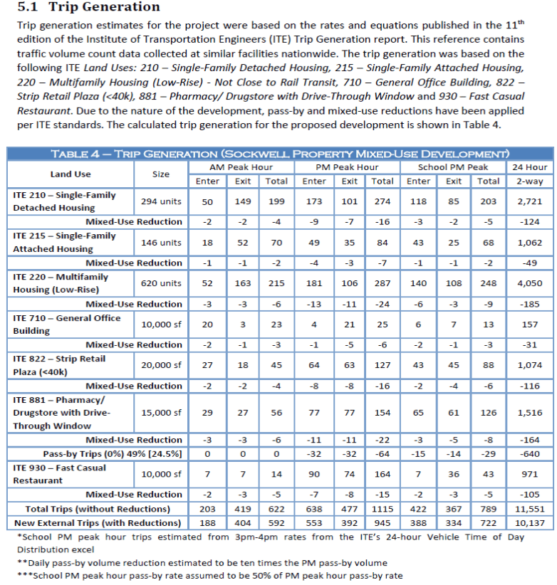
Traffic Study (page 9)
Conclusion (page 10)
The approximately 158 acres is currently undeveloped. Pursuant to the Emerging Suburban, Village Center and Live/Work Character areas appropriate land uses, a CORD-PRC is a suitable land use request.
A development of Regional Impact was completed by the NEGRC. The Commission found no
adverse effects the project might have on the surrounding region according to their Regional Plan’s six characteristics that benefit the region’s people. These characteristics were as follows – 1. Enhances economic mobility and competitiveness, 2. Elevates public health and equity; 3. Supports and adds value to existing communities; 4. Creates housing that is diverse, adequate, equitable, and affordable; Includes transportation choices and, 6. Is well-connected with existing and planned transportation options.
The commission however recommend interconnectivity with adjoining parcels and that the developer should consider adding a second access point to Hwy 278 to provide better traffic flow for entering and exiting the western side of the development.
The Development being proposed will consist of mixed uses (residential, commercial and recreational walking paths). The mixed use development will consist of 35,000 square feet of commercial space, 294 single family detached lots, and 146 townhome units. Five (5) “flex units” are proposed in the mixed use area, which would include 180 condominiums and office and commercial space. A traffic study was completed and the report stated that there will be a total of 592 A.M. peak hour trips, 945 P.M. peak hour trips and 722 school P.M. peak hour trips.
While the request to rezone to a CORD-PRC is compatible with the County’s Character areas in the 2023 Comprehensive Plan and with the NEGRC Regional Plan, it lies in the Alcovy River watershed. This watershed specifies a minimum lot size of 2 acres. The applicant is requesting a higher density with a compact design which will preserve approximately 50% of the development.
The proposed development lies in the Alcovy River watershed. While most of the suggested zoning requirements as stated in the proposed design standards of the development comply with Division 300 for a CORD, there are some that do not meet the minimum development standards. The minimum lot size in a CORD defaults to the underlying zoning of AR which is 2 acres due to the Alcovy watershed. The proposed average minimum lot size for the single family homes is 7800sf. The density for single family homes would also default to the AR (Agricultural Residential) base zoning of 1 unit per 2 acres. The base density for townhouses is 8 units per acre. The proposed density for single family homes is 4.9 units per acre and for townhouses the proposed density is 11.85 units per acre. The side setbacks for the CORD-PRC zoning is 7.5 ft and 15 ft for corner lots. The development is proposing a reduced distance of 5 feet and 10 feet for the corresponding setbacks.
[Please read the rest of the Conclusion in the PDF on page 11.]
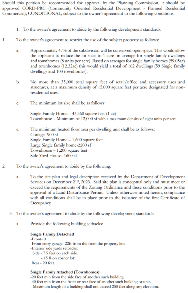
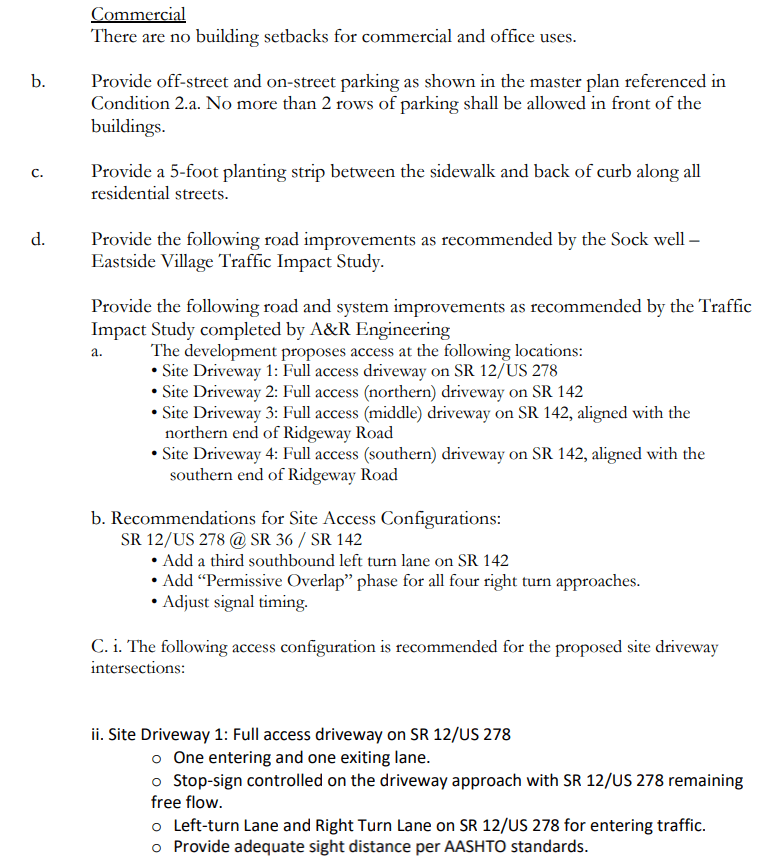
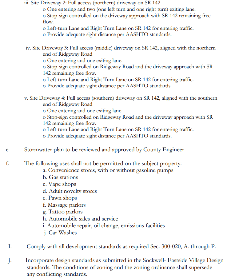
Recommended Conditions (pages 12-14)
Concept Site Plan (page 23)

One response to “Hwy 278 & GA 142 Intersection Zoning Change Request”
[…] and “Sockwell Corners” Developers requested REZ24-000001 (Hwy 278/Elks Club Road) and REZ24-000002 (Hwy 278/ GA 142) be tabled until April 2024. That means the Board of Commissioners will not hear […]
LikeLike